Almost immediately upon entering the Sudbury River's Cut-off Oxbow this past Wednesday I was thankful for the relatively high water level in the river (7.8' at Saxonville gauge). Thus, instead of just having the usual options of paddling either upriver or downriver from the end of Little Farms Road in Framingham, MA, I was provided with a third choice which was to detour from the river's main channel and enter the mile-long cut-off oxbow. Soon after entering the oxbow's upriver entrance I noted what looked to be a dead or possibly sleeping deer. Before I could grab my camera, the animal awoke and I found myself eye to eye with an adult coyote. This guy seemed to have an unusually large front quarter compared to his hind quarter. Looked more wolf-like than most of the coyotes I've encountered. We went our separate ways.
The coyote was probably taking advantage of all the creatures using the oxbow as a nursery these days. There was a heron rookery of about 10 nests. Almost all, including this one, were occupied...
The rookery brought to mind Dr. Seuss...
An unattended egg-laden ground nest perhaps of Canada geese...
Sadly this good-sized snapping turtle didn't survive his last winter...
An immature hawk...
...having to cope with being buzzed by what I believe is a tree swallow...The Oxbow (cut-off since the 1950s) provided this paddler with a unique experience: plenty of wildlife, a reduced/relaxed current, and a sense of solitude not often found. I felt like a guest in a place unintentionally set aside for other creatures by humans who preferred taking the shorter, more direct route through the cut. On July 31,1859 Henry David Thoreau boated up the Sudbury River and upon reaching the Oxbow Thoreau noted in his journal: "At about one mile below Saxonville the river winds from amid high hills and commences a great bend called the Ox-Bow. Across the neck of this bend, as I paced it is scarcely twenty rods, while it must be (as I judged by looking, and was told) a mile or more around. Fishermen and others are accustomed to drag their boats overland here, it being all hard land on this neck. A man by the bridge below had warned us of this cut-off, which he said would save us an hour." A few days later on August 3rd he noted "The most remarkable bend between Framingham and the Dam (Billerica) is the Ox-Bow in Framingham". These Thoreau journal entries were found on the Walden Woods Project's website.
Map showing the Oxbow...
Following completion of the mile-long loop I found myself back at my starting point. From there I headed upriver against a steady current. Noted a school bus was now in the parking lot and groups of students and their instructors were dispersed along the riverside nature trail...
Went up as far as Cochituate Brook...
...where the high water allowed me to get within sight of the School Street bridge...Back on the Sudbury River and heading downriver I passed beneath the Danforth Street Bridge originally built in 1890...
Today it survives for use by pedestrians only. At the downriver end of my visit was the Stone Bridge...
...where this historical marker at the bridge's east end notes the passage of Colonel Knox's "noble train of artillery" in early 1776...Additional rainfall on Friday and Saturday raised water levels still higher. When the rain finally stopped on Saturday afternoon the Assabet River's gauge at Maynard had risen to 4 feet leading me to wonder if paddling over the tops of beaver dams in Nashoba and Fort Pond brooks might be possible.
To find out I launched into Warner's Pond in West Concord, MA...
...and headed to where Nashoba Brook enters the pond. Paddled up the swollen brook to the confluence of the two brooks (Fort Pond Brook to left, Nashoba Brook to the right)...
Just beyond the confluence is where the Bruce Freeman Rail Trail crosses over both Nashoba Brook and Route 2. Any thoughts of heading up Nashoba Brook were dashed by inadequate headroom under the odd looking I-beam structure...
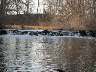
Fort Pond Brook was my only option and upon reaching the abandoned roadway bridge I saw the substantial beaver dam blocking the brook just above the abandoned bridge (photo shows how it looked last December)... ...was now completely submerged thanks to all the rain...
Red-winged blackbird males were intent on being seen...
...and competing with each other
Followed Fort Pond Brook's winding course for about 0.75 miles...
The swift current and a gusty breeze made the trip back to Warner's Pond almost effortless.Map showing Warner's Pond, Fort Pond and Nashoba brooks...


No comments:
Post a Comment