Friday, September 30, 2011

Things Looking Good on Bruce Freeman Rail Trail

Mrs. Trashpaddler and I were fortunate enough to get in some biking this morning on the Bruce Freeman Rail Trail in Chelmsford.  We covered the section from the Westford/Carlisle trailhead to Chelmsford Center and noticed several improvements since our last visit.  Unfortunately, I left my camera at home and wasn't able to get photos.  Therefore, I'll describe them: 
  • A new parking/trail access is being constructed in South Chelmsford on Robin Hill Rd. and looks very close to completion. 
  • At Ginger Ale Plaza near Chelmsford Center there is a bicycle repair station.  It includes a trailside elevated platform, an air pump with gauge, and basic bicycle tools that would facilitate such repairs as a flat tire, seat adjustment etc.  I thought this was great and far beyond what I would've expected to see.
This trail keeps getting better!

Very little trash was seen today and what there was was mostly found in clusters at 2 locations.  The total was 19 recyclable containers.  They stopped in my backyard for a respite on their way to the recycle bin...


I explained to the plastic contingent how our Massachusetts legislators can't update our bottle bill because they are too busy debating (salivating) how they will soon get their hands on state run gambling casinos and slot machines.  Imagine the nerve of State Senator Jamie Eldridge (from my town of Acton) in proposing a moratorium on legislators working for gambling interests in the first five years following their exit from public service.  After the resulting brouhaha, legislators whittled his proposed moratorium down to 1 year. 
This sounds like a disasterous gamble to me.  The federal government granted gaming rights to Native Americans for a good reason.  We owe it to them.  The Pequots, with their Foxwoods Casino have shown how well Native Americans can run such an operation and the state of Connecticut has received a healthy percentage of the take. 
Massachusetts should allow the Wampanoag people to build and operate a casino similar to Foxwoods and Mohegan Sun.  Keep the legislators out of it as they have shown repeatedly that integrity is not their strong suit.  Massachusetts will still get a fair share of the take and prevent even more scandals by not being in the casino business.  Kudos to Mr. Eldridge for anticipating a potential fiasco.

My YTD total now stands at 5139.

Wednesday, September 28, 2011

Paddling Stony Brook in Westford

It seems as though our summer season is in triple-overtime and days like these are just too good to waste.  So, after an afternoon appointment brought me to the town of Westford, I decided to paddle a small portion of Stony Brook.  The brook, which runs from Forge Pond to the Merrimack River in Chelmsford, seems more like a small river than brook to me.  After launching from the River Street Boat Launch, I headed downstream past a few obstacles in the form of downed trees and beaver dams.  Almost immediately ducks were flushing out from all around me...both wood ducks and mallards.  Ospreys were seen repeatedly such as this bold fellow checking me out...


The local blue herons had a fondness for tree perching as well...

With the afternoon fading fast, I turned around sooner than I would have preferred and returned to River Street.  I definitely plan to return to this waterway with better gear for beaver dam hopping.

There were 21 pieces of floatable trash recovered today...

Composition was: 19 recyclable containers (3 redeemable) and 2 pieces of rubbish.  YTD total stands at 5120.


Tuesday, September 27, 2011

Signs of Hope for Litter Prevention


There were two of these signs at the location where I launched from yesterday and the site was cleaner than I've ever seen it.  The signs mention Pat Conaway and provide this link to his organization.
I tip my hat to Pat for the obvious cleanup at the Little Farms Road boat launch and the additional follow-through the signs encourage.


Today, on yet another bonus summer-like day, Mrs. Trashpaddler and I biked the Nashua River Rail Trail from Ayer to East Pepperell.  Trash, mostly of a plastic nature was scattered along the bike path...


Lastly, a photo of my boat's cargo from yesterday...


The combined total was 58 bringing YTD total to 5099. 

Monday, September 26, 2011

Sad Day on the Sudbury River in Framingham

Today's paddle on the Sudbury River started out in typical fashion.  I launched into the Sudbury River at Little Farms Road in Framingham and headed up river doing the things I usually do.  I was planning to turn around at the mouth of Cochituate Brook but, for some reason, elected to continue upriver.  After passing under Concord Street and the river gauging location, I reached the spot pictured at left and came upon a scene that no paddler ever wants to encounter. Where a fallen tree was acting as a strainer, a deceased woman's body had become entangled.
I called 911 on my cell phone and the Massachusetts State Police answered.  After explaining the nature of my call, they connected me with the Framingham Police Department, who shortly arrived near the scene.  Because of the very steep and overgrown embankment, a small zodiac was called for and journeyed upriver from Little Farms Road...

At this point, I returned downriver.  It was a somber trip and my prayers and thoughts are with the family of the deceased woman.


More information can be found at this link.

Saturday, September 24, 2011

Pompositticut Paddling on the Assabet River


While it may be starting to look like autumn in some spots, it sure felt summery this afternoon on the Assabet River in Stow.  Cloudy skies were expected, but the sun decided to put-in a late day appearance and heat things up considerably.
I launched at Russell's Bridge (White Pond Rd.) and headed upriver to Fort Meadow Brook before returning.  Green herons seem to like this stretch of river and several were seen...

Pairs of mute swans were seen...

Great egrets were also about...


And an osprey...

Also seen were a belted kingfisher, numerous wood ducks, blue herons, painted turtles, and a tail-slapping beaver.

This new structure, I'm guessing, will be a mosquito-free duck blind...

Trash was on the light side until a cluster of Bud-light cans were recovered from the riverbank.  The count for this day was 32.  There were 26 recyclable containers (24 redeemable) and 6 pieces of miscellaneous rubbish which included some kind of cylinder...
YTD total stands at 5041.


Thursday, September 22, 2011

Great Swamp Paddling in Narragansett Country

Yesterday, in the predawn hours,  I traveled to Rhode Island's Great Swamp for some paddling and terrestrial exploration.  It was Nathaniel Philbrick's book Mayflower and his account of this place and the event that occurred here in December 1675 that compelled me to experience the area first hand.  In history written by the colonists, the event is referred to as "The Great Swamp Fight", whereas the Narragansetts remember it as the "Great Swamp Massacre".  The area in question envelops 3,349 acres and is shown on this map.
I launched into the southeast corner of Worden Pond as the sun was just illuminating Stony Point (opening photo), across the pond to the northwest.  The pond's surface was like a mirror as my boat and I sliced our way over to where the Chipuxet River enters from the northeast.  A pair of mute swans helped in guiding me to the spot which is not so easy to discern.   Ascending this small river, it began to look more like a stream...

Proceeding upstream required pushing over a small beaver dam, and scaring a bittern in the progress.  After about a half mile or so, I found out why water had been in such short supply...

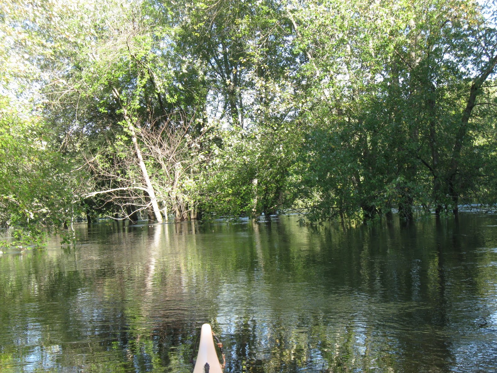
This beaver dam was substantial and required exiting, lifting over, and re-entering my boat.  Above the dam, the Chipuxet was more like a river and wood ducks were encountered upon rounding each succesive bend...

 Large clusters of these yellow flowers were greeting the morning's sunshine...


After surmounting another substantial beaver dam, I passed under some power lines and the bridge which once carried trains of the Narragansett Pier Railroad (now a bike path), before reaching my destination of Taylor's Landing...


Here I stopped for an early lunch near the intersection of Rt. 138 and Liberty Lane.  The trip downriver went a little faster, though I did have concerns about fairly close gunfire, just upstream of the power lines.  Seems a little early to be hunting season.  Once I dropped below the second beaver dam, it was back to paddling more grass than water...


Wildlife encountered on the trip downriver included tree swallows, woodpeckers, a kingfisher, a heron, wrens, turtles, a kestral, 2 hawks, and a water snake sunbathing on the smaller of the 3 beaver dams.
Once back into the pond, I paddled to Stony Point, and on the way, the haunting call of a loon was heard from near Tefft's Island.
Following some leg stretching at Stony Point I continued heading west in search of the Pawcatuck River and the spot where it leaves the pond.  It was easier to find than the Chipuxet and the current leaving the pond was clearly seen and felt.  I paddled only about a quarter mile down this river before deciding to begin my paddle back to my put-in location.  This was the view from the Pawcatuck as I returned to the pond...
  
It was mid-afternoon when I arrived back at the Worden Pond Launch...

With my boat cartop again I drove west on Worden's Pond Road to Biscuit City Road to Route 2 north and began carefully looking for Great Swamp Monument Road.  There is little to mark the entrance and the .7 mile dirt road soon transitions to something more typical of a fire road.  After about half a mile there is a circle around a bunch of trees with nothing else.  Out of this strange circle the path continues to the south and finally arrives at one of the more interesting monuments I've ever seen...
This uninscribed granite obelisk reaches toward the sky and is surrounded by 4 stout granite blocks and 2 plaques at ground level.  The site looks neglected and the plaques are in rough shape.  In fact one is missing completely.  The monument was installed here by the Rhode Island Society of Colonial Wars in 1906.  The 4 stout blocks each represent a colony and are so inscribed: Connecticut, Massachusetts, Plymouth, and Rhode Island (odd since it is my understanding that Rhode Island did not officially participate in the event).  The remaining plaque is hard to read...

Thanks to Historical Marker Database the original wording can be found.

I was left to stand there in this lonely and forsaken spot and ponder what occurred here.  A large number of Narragansett people were hunkered down for the winter inside a large (5 acre) pallisaded fortress.  There were several hundred wigwams inside the fortress.  The war known as King Philip's War was underway and it pitted their neighbors the Pokanokets against the colonists.  The Narragansetts had somehow managed not to be drawn into the conflict.  However, because they provided refuge for some of the Pokanoket women and children, the colonists declared war on them and launched a pre-emptive attack on the fort December 19, 1675.  A force of 1,000 men drawn from the 3 colonies attacked the fort and battled the Narragansett warriors for several hours before prevailing and capturing the fort.  This part is known as the "Great Swamp Fight". 

It was what happened following the battle that is disturbing, and an example of history as told only from the victor's perspective. The colonial army now possessed a fort containing hundreds of wigwams in which there were women, children, sick, and old.  There were also many injured soldiers, and darkness was approaching rapidly.  There was a debate as to whether they should stay in the fort until morning, or destroy the fort and march back to Wickford in the dark.  The commander, Gen. Josiah Winslow hesitated and the debate became mute as soldiers had begun torching the wigwams.  Soon the darkness was filled with screams from within as hundreds of non-combatants were trapped in the wigwams.  Perhaps this part should be known as the "Great Horror".  It's amazing what humans are capable of once they dehumanize an enemy.
The soldiers claimed the flames from the inferno lit their way for several miles.


According to the 1861 book Indian Names of Places in Rhode Island by Usher Parsons, M.D., the Narragansett name for Worden Pond was Aquabapaug and the Narragansett name for the monument locale was Quawawehunk.  Parson's book can be found online at this URI site.

While subsequently visiting the web site of the Narragansett Tribe, I saw listed under News/Events that the tribe will be conducting a Great Swamp Pilgrimage this Sunday, 9/25/11. Quite a coincidence!

I found much useful information on paddling in the Great Swamp at this link regarding Jim Cole's favorite Rhode Island paddle. 


A modest amount of trash was recovered from the various sites I visited today...

There were 14 recyclable containers and 25 pieces of miscellaneous rubbish.  Total of 39 bringing YTD total to 5009.


Sunday, September 18, 2011

Concord River - Egg Rock to Buttricks Hill

While the calendar may say it's still summer, it sure felt like fall late today on the Concord River.  The sun seemed to almost drop out of the sky, much too early for my liking.  My short patrol produced a modest haul of 36 pieces of trash.  There were 16  recyclable containers (4 redeemable) and 20 pieces of miscellaneous rubbish such as plastic bags, styrofoam, nip bottles, and a plastic pail.  Due to the earlier onset of darkness, they were blinded by the flash...

YTD total stands at 4970


Wednesday, September 14, 2011

Another Pompositticut Daybreak


With the sands of summer moving fast to the bottom half of the season-glass, it was nice to greet such a warm morning as it dawned on the river.  The moon was still visible on my right as I paddled upstream on the Assabet from Sudbury Road in Stow.  Water levels are still quite high and the current remains strong and steady.  A pair of green herons were seen first followed by an osprey, a great egret, and this beaver heading home after a hard night's work...
Later, numerous wood ducks, blue herons, turtles, and mute swans would be seen.

The sun was just clearing the treetops and there wasn't a cloud in the sky as I continued upriver...

Just before reaching Rt. 62 in Gleasondale, this recent blowdown blocked most of the river...


One benefit of such high water was being able to paddle to within eyesight of the footbridge and dam...

The downside of the high water was all of the trash it has on the move.  There was a fair amount of it snagged behind fallen tree limbs.

High water may also have played a role in this bee's nest being broken...
A tree swallow kept trying to hover near the nest which was still buzzing with bees.  The bees soon had him flinching and leaving the area.  I'm not sure if he was after the bees, their honey, or the many berries around the nest.

Once back to Sudbury Road, I continued downriver to Crow Island and enjoyed this view...

The Assabet River flowing through Stow is the section that I find most pleasing to paddle.

In the backwater below the island an automobile tire was partially afloat.  It topped my haul for the day at 85 pieces and joined the rest hullside for a photo...
Today's haul was composed of 42 recyclable containers (11 redeemable) and 43 pieces of miscellaneous rubbish such as styrofoam, plastic bags, nip bottles, parts of a brute barrel, and the tire.  YTD total stands at 4934.  Thanks to the Stow Highway Department for allowing the tire to be added to their used tire inventory.
 

Monday, September 12, 2011

Farewell to Summer's Last Full Moon


Mrs. Trashpaddler and I decided to watch this summer's last full moon climb above the treetops while afloat on the Sudbury River.  Our vantage point was Martha's Point.  Paddling further upriver into Fairhaven Bay found the moon higher still...


The sun had set quietly about 25 minutes earlier...

And in the interim, there was just enough light to roundup 4 more bait tubs, a plastic jug, and an empty fish hook package at Heaths Bridge...
YTD total 4849.

On our return trip downriver, we heard a chorus of owls at Martha's Point, some loud disputes amongst the heron population, and nearly a dozen beaver tail slaps.   We were also followed by a good deal of moonshadow!


Saturday, September 10, 2011

April-Like Conditions on Lower Assabet

Egg Rock wasn't able to tell its usual story "On the Hill Nashawtuck, At the Meeting of the Rivers....." this morning due to April-like water levels having submerged the inscription.  The alternative message was "The Assabet River is chugging on by and the Sudbury River will have to wait its turn."
Dove Rock was under water and Willow Island was awash...

In addition to the Assabet being in a hurry, she'd also done some rearranging of furniture.  Several past blowdowns had been shifted to new positions.  Trash was also on the move except where stragglers had become trapped behind some fallen limbs.  This snag provided some one-stop trashpicking...

Spencer Brook provided some relief from the river's current and allowed me to negotiate its twists and turns to within a stone's throw of Barretts Mill Road.  Strange for this time of year.

Upon reaching West Concord, I was looking for a place to land and take a break from paddling against the current. This recently improved canoe/kayak launch at the former Dee Bus facility filled the bill nicely...


Passage under Pine Street was much easier thanks to the new bridge's single span as opposed to the old bridge's mid-channel support which created 2 funneling flows.

I ended my ascent near this old blowdown behind the Thoreau School...
The trip downstream was a speedy one at between 6 and 7 mph.

My day's catch of 66 posed in the sun at the Calf Pasture...
There were 41 recyclable containers (12 redeemable) and 25 pieces of miscellaneous rubbish such as a 5-gallon plastic pail, a broken flask, a soccer ball, styrofoam, nip bottles and a plastic bag.
My YTD total stands at 4843.

Trashpedalling Cape Cod's Rail Trail

Mrs. Trashpaddler and I weren't going to let a little rain keep us from enjoying some biking on the Cape Cod Rail Trail this past week.  We started at the Wellfleet Trailhead and worked our way towards the other trailhead at South Dennis, a distance of 22 miles.  It was our first time pedalling on this rail trail and we were left thoroughly impressed.
While in Wellfleet, we ventured a short distance down Marconi Beach Road to the Marconi Site, part of the Cape Cod National Seashore, and took in this view of the Atlantic Ocean...
It brought to mind George Costanza saying "The sea was angry that day my friends..." 
Several gray seals were seen in the surf (none with golf ball problems).

Also at the Marconi Site, was the Atlantic White Cedar Swamp Trail where a short hike brings one into the midst of a cedar swamp...

Between Wellfleet and South Dennis, we pedalled by cranberry bogs, tidal creeks, salt ponds, the Herring River, and our first ever bicycle roundabout (in Harwich).

Numerous locations along the way still bear Native American names such as Nauset, Aspinet, Samoset, and Namskaket.  These names remind us how this part of Cape Cod was once home to the Nauset tribe of the Wampanoag Federation.  It was the Nauset people who first encountered the Pilgrims back in 1620. 

The Cape Cod Rail Trail is well maintained and pieces of trash were few and far between.  Over the course of 3 days and pedalling 44 miles we recovered only 50 pieces of trash...
 
 YTD total stands at 4777.