Saturday, May 27, 2017

The Otter's Missing Link

The car to the right of the beaver lodge is traveling west on Route 2 in Gardner, Massachusetts.  I've driven this same stretch many times and wondered about the river flowing under the highway.  Signs on the highway identify it as the Otter River.  On several occasions, after passing over it, I'd go to Google maps in hopes of finding out more only to find no trace of a waterway crossing Route 2 at this location.  Did I really see one?  Google Maps does show the Otter River from its confluence with the Millers River up to the Cummings Conservation Area in Gardner where it mysteriously disappears.  There's no sign of it where it crosses under Routes 101, 2A, and 2.  While it is a small river it's not that small.  The Otter River then re-appears on Google Maps in Hubbardston near Pitcherville Road.  Tributaries to the Otter such as Pond Brook, Foster Brook, Hubbardston Brook, and Templeton Brook are all shown just ending without connecting to anything...almost like the new interpretation for determining our nation's navigable waterways.

Fortunately, I recently stumbled upon an online map of the Otter River Headwaters Blue Trail by the Millers River Watershed Organization, and yesterday that map brought me to this spot in East Templeton...

The rain showers I expected to see coming to an end were doing just the opposite as I launched from Plant Road.  Heading upriver I passed quite a gathering of male wood ducks...
They were hanging around this "Tiki Hut" looking duck blind...
...which reminded me of Gilligan's Island.

I'd traveled only .75 miles upriver when I came upon this situation at Route 2A...
A blockage of some type had the water on the upstream side higher than the downstream outlet.  Fast current and low head room resulted in an unplanned portage which after a quick scouting turned out to be shorter and easier than expected.

A little further along I had 3 corrugated culverts to choose from in passing under Route 2...

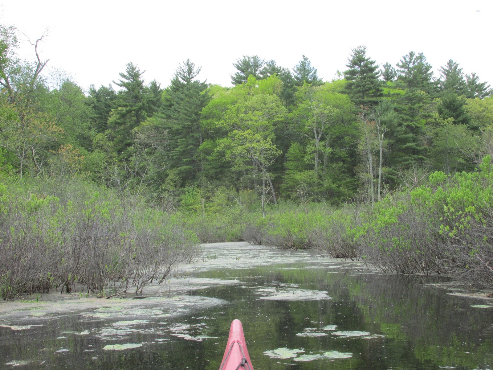
Emerging on the other side I entered the Otter River Conservation Area and felt any and all efforts to this point were worth it...


Continuing past the conservation area required a turn to the west and 2 beaver dam up and overs before reaching the end of navigable water...
...at this spot southeast from an airport runway and about 3 miles upriver from Plant Road.  The view is towards Hubbardston.  Here my camera succumbed to the moisture and stopped working.  My return trip did include one encounter with an actual otter, and seeing a female wood duck exit a box nest upon my approach.  Both of these events were so sudden I doubt I would have got a photo even if my camera did cooperate.

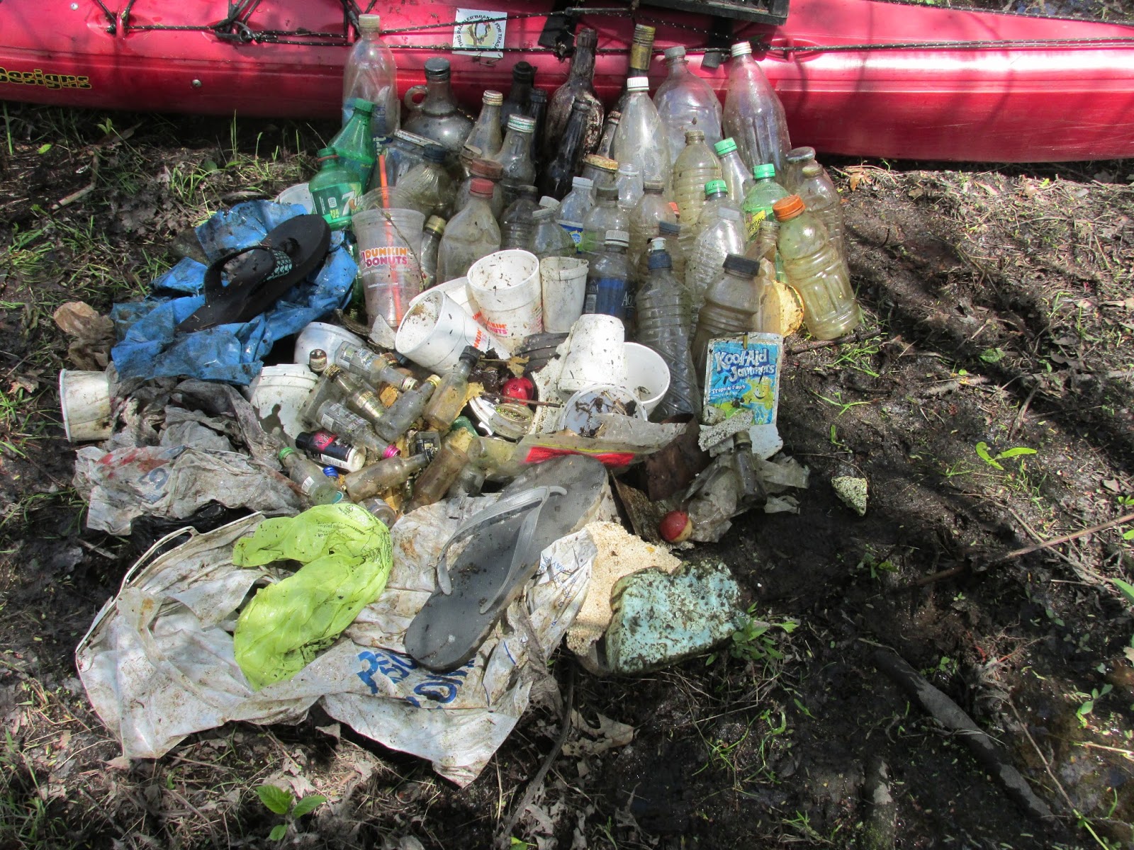
Once back at Plant Road my backup camera was pressed into service to record this bit of recovered flotsam...

The Otter River Headwaters Blue Trail made for an enjoyable exploration on an otherwise gloomy afternoon.  Way better than sitting on the couch waiting for the rain to end. 

Going downriver from Plant Road would have required squeezing under a large pipe crossing the river.  I'll save that for my next visit.

As to why Google Maps is missing about 5 miles of the Otter River I have no idea.  Perhaps I'll Google it.

Sunday, May 21, 2017

Cool Assabet/Hot Fairhaven

This morning the entire text of the Egg Rock inscription was above water indicating that water levels have dropped about 6 inches since my last visit on 5/7.  That translates into more shore-front property for these new editions to the Canada geese population...

... and afforded a shady spot for this white-tailed buck to wile away the afternoon...

Debris falling into the river was traced back to this pileated woodpecker...

Work has begun in West Concord on preparing another section of the Bruce Freeman Rail Trail.  The old New Haven Railroad grade has been cleared to the point where a bridge may once again span the Assabet...

Today's haul of trash...


Unlike today's cool temperatures last Thursday was day two of our first heat wave of the season.  I found some relief from the 94 degrees on the Sudbury River and Fairhaven Bay.  I moved slowly as my acclimation to high heat is still in progress...
...but I'm not complaining.  I'll take heat over cold any day!

Found some temporary shade with a great view of the bay...

From the bay's northeast corner I paddled a bit in the general direction of Walden Pond...
...until stopped by a beaver dam...
 
...where I noted some flow coming through the dam.  At that point I was only about half a mile from Walden Pond.

Not much trash on Thursday...

Tuesday, May 16, 2017

Broadmoor's Brook

The rain finally let up yesterday just as I finished my last job near the Charles River in Sherborn.  Thus an opportunity to paddle from Farm Road (photo above) down to the Broadmoor Wildlife Sanctuary owned by the Massachusetts Audubon Society.  Once there I ascended Indian Brook passing thru this spot where the brook was funneled...
...perhaps the site of an earlier dam or fish weir?

Naturally, wildlife was present...
This white-tailed deer stared me down for quite awhile...at one point making a series of head nods, before going back to feeding.

Red-winged blackbirds were plentiful...

As well as orioles...

On my way back to Farm Road a second deer was seen...

Most of the trash encountered was at or near the boat launch...

Saturday, May 13, 2017

Staying Above the Rocks

  
Following a week of tumultuous news, I sought refuge from it all by getting out on the Charles River yesterday.  Launched at South Street in Needham and headed upriver intending to explore some of the river above Chestnut Street which I'd yet to experience.  
 
Along the way I encountered this fellow who was staying close to the safety of his burrow... 


He did inch-out a bit perhaps to hear the latest developments...

This mink was busy both in and out of the water...

Made it up to about a half mile below Cochrane Dam where things got shallow and rocky.  My ride back down to South Street was a swift one.

The section of the Charles paddled yesterday was relatively free of trash and I might have been skunked if not for this "party" bag full of empty beer cans and Solo cups...
...and this once "happy" Mylar balloon...
...resulting in this haul...

Who drinks canned beer from Solo cups?

As to recent developments, I confess to dreading that we're inching closer and closer to something that I sense won't be good. 

Monday, May 8, 2017

Assabet Along Nashawtuc

Yesterday was yet another windy day around these parts and I chose to paddle the section of the Assabet River between Egg Rock  and Nashoba Brook.  This includes the stretch described by Nathaniel Hawthorne in Mosses from an Old Manse as follows: "It is sheltered from the breeze by woods and a hillside; so that elsewhere there might be a hurricane, and here scarcely a ripple across the shaded water."
The hillside providing much of the shelter is Nashawtuc Hill.

Once past the most sheltered section I saw a few more trees recently blown down into the river (opening photo).  

Before ascending the Assabet a quick check of the Egg Rock inscription showed the water level underlining the Native American name for this place "Musketaquid"...

Two recently installed buoys were seen, one at the confluence of the Assabet, Sudbury, and Concord Rivers and the other on the Assabet beyond the Leaning Hemlocks...

This year's edition of little geese are running around on the riverbank...

By the time I reached Nashoba Brook this fair amount of trash had been collected...
...empty plastic bottles and bags, Styrofoam cups, quite a few nip bottles, a few glass bottles, and there's a third mis-matched flip-flop in there somewhere.

Saturday, May 6, 2017

A Little Shawsheen Redemption

That's what we participated in on this showery Saturday morning.  We'd responded to an invitation from Justin, President of the Shawsheen River Watershed Association.  By we I mean the usual gang from the New Hampshire AMC Paddlers: Denise, Gary, Maureen, Paul, Ron, and Sue.  Denise was starting her 5th season of "First Saturday (of the month) Trash Patrols" and Justin's invitation coincided nicely in giving us a new river on which to kick things off.

We started from Pinehurst Park in Billerica by Route 3A.  Some of us headed downriver while others headed upriver.  In addition to the usual trashy flotsam, Justin wanted to work on removing some tires from the riverbank.  I think woodchucks would've approved of our digging and root cutting efforts in tire excavation.

The trash gathered from the upriver section is pictured above along with Denise, Gary, Maureen, Sue, Ron, and Justin (in waders).  Paul may have still been out on the water.

It would've been hard not to be impressed with Justin's boundless energy and enthusiasm.  It's infectious!    

Thursday, May 4, 2017

Getting May Underway


Paddled a bit of the Concord River today from Route 225 in Bedford upriver to Saw Mill Brook and back.  Water levels are still a little on the high side and with one to two inches of rain forecast for tomorrow they'll be going even higher.

The boat launch was a fairly busy spot with canoes, kayaks, power boats, and shore fishermen.

A new kiosk is in place across from where the old one stood...
The solar powered Big Belly trash and recycling compactors have been replaced with a more traditional trash receptacle.

Trash was on the light side...