I wasn't planning another trip to Vermont this fall...but then I came across A Prehistoric Inventory of the Upper Connecticut River Valley by Daniel Cassedy. One of the sites he listed in his inventory was the Skitchewaug Site alongside the Connecticut River where Native American corn found in storage pits was radiocarbon-dated back 1100 years. Because of this he wrote that the site was "...one of the most significant sites currently known in the Northeast." After reading this it took only a few weeks until I found myself looking upriver from the Skitchewaug Site shoreline this past Sunday morning (above photo).
I'd launched at the confluence of the Black and Connecticut rivers at about 8am. The air temperature was about 40 degrees whereas the water being much warmer resulted in considerable fog ...
The Skitchewaug Site is located where a fertile floodplain stretches from the mountain's base over to the Connecticut River...
In a paper for the Journal of Vermont Archaeology (Vol. 12, 2011) titled Western Abenaki of the Upper Connecticut River Basin: Preliminary Notes on Native American Pre-Contact Culture in Northern New England R. Duncan Mathewson III states "Quite clearly Skitchewaug Site represents a major village settlement on the west bank of the Connecticut River some 500 hundred years before Contact times and into the Protohistoric Period." Hard for me to wrap my head around the fact that Native Americans planted and harvested corn in these fields for eleven hundred years. That's more than 13,000 full moon cycles!
Further upriver the floodplain widens out even more and these few remaining corn stalks...
...speak to one of Mathewson's conclusions: "The presence of corn in all seven storage pit features at Skitchewaug has been interpreted by Heckenberger et al. (1992) as indicating that corn was an important diet staple rather than simply a diet supplement."
Returning to my boat I found the sun finally breaking through the fog and the day was improving by the minute. I followed the river bank up as far as the now submerged (I guess) Glidden Island before heading back downriver. The view of Skitchewaug Mountain from near where Glidden Island used to be...
The person having the best view of Skitchewaug Mountain and the river alongside it was this guy...

On the way and about a half mile below Skitchewaug I thought about the Wentworth Ferry and the role it played in linking sections of the Crown Point Road which connected the Fort at No. 4 in present-day Charlestown, NH and the fort at Crown Point on Lake Champlain. Soldiers beginning the trip from the Fort at No. 4 on the New Hampshire side would march about 2 miles to a point where the ferry would take them across the Connecticut to the Vermont side. The only spot I could find on the river's west side where the riverbank looked suitable for a ferry landing was this one...
It's approximately 900' south from these two historical markers:
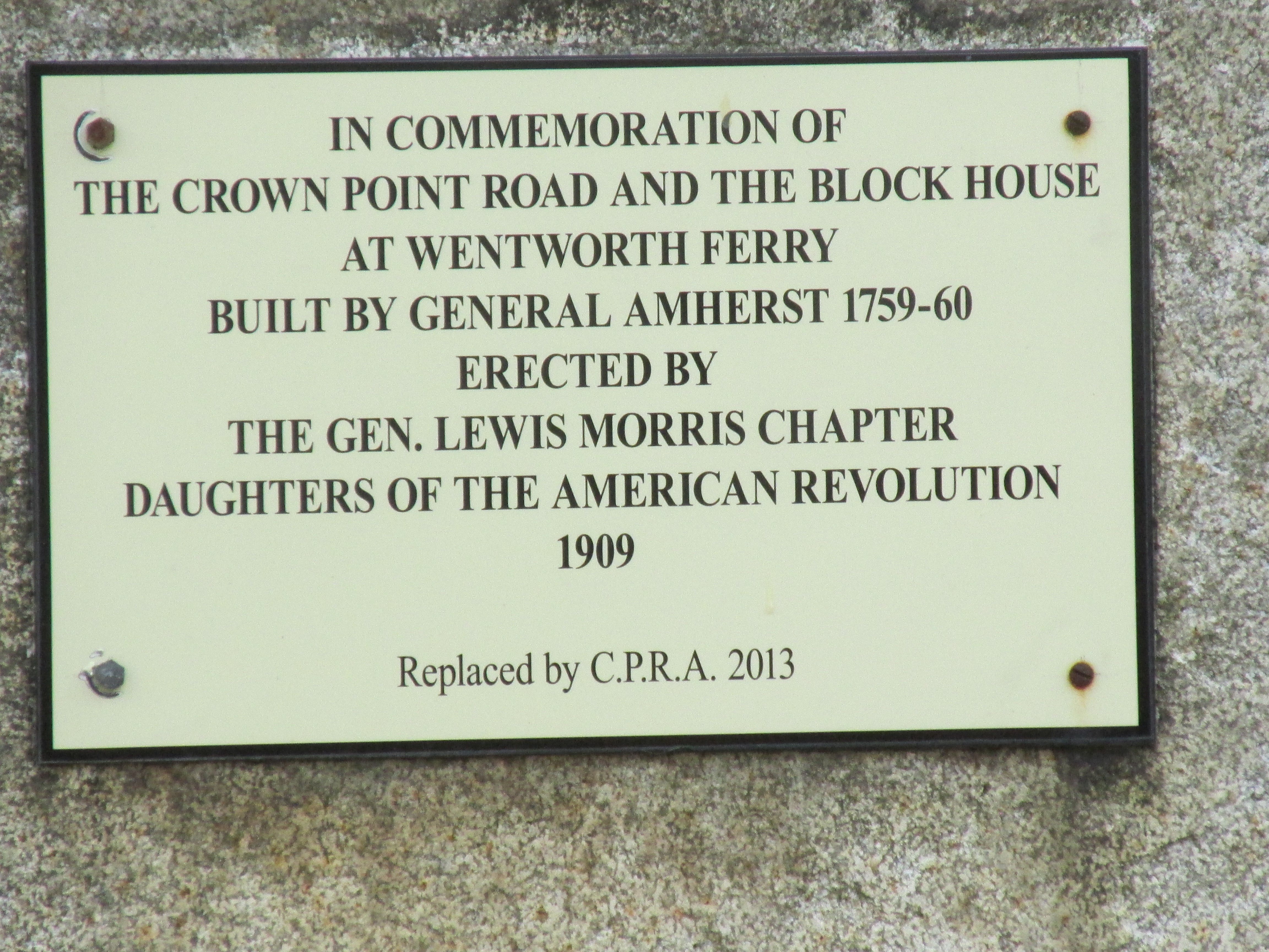
A plaque on a large stone pertains to both the ferry and the Crown Point Road...
...and an additional marker for the road...

According to the Crown Point Road Association the road was built per the order of British General Jeffery Amherst upon his having gained possession of both Ticonderoga and Crown Point, both key forts on Lake Champlain during the French and Indian Wars. In order to advance further north towards French controlled Canada he needed a reliable supply route to and from the Fort at No. 4 some 70 miles to the southeast. Part of his order for building the road stated "...the most direct line possible to No. 4 clearing the forest all the way you go and widening it in every part to at least 20 feet....". On the association's website, crownpointroad.org, there are GPS coordinates for the road's remaining stone markers. The coordinates were recorded by Hunter Melville and are a great help to those looking to locate them.
On my drive home I visited some related historical markers in Charlestown, NH near the spot where the Crown Point Road terminated at the original Fort at No. 4...
Fort at No. 4 was actually located about a mile and a half south of the fort's present-day replica.
This additional marker mentions Gen. John Stark's 1777 march to the Battle of Bennington...
His route to Bennington is known to have taken him through Manchester VT leaving me to wonder if he and his men crossed the Connecticut via Wentworth's Ferry and followed the Crown Point Road for part of the way. If so, it would have been fitting as he'd played a role in building the Crown Point Road some 18 years earlier.
Earlier last week I got out on the Sudbury and Assabet rivers. The Route 27 Bridge over the Sudbury in Wayland showed some fall colors...
...and an osprey did some fishing...
My paddle on the Assabet River in Stow provided additional fall foliage at the Assabet Overlook...
...and the Assabet showed plenty of wildlife with swans, ducks, geese, as well as this hawk...
...and this white-tailed deer wearing its darker winter coat...
My photo of trash from the Sudbury River was accidentally deleted but consisted of the usual culprits... half a dozen or so plastic bottles.
Trash from the Assabet...
Sunday's trash from the Connecticut River also known as the "Kwenitekw" to the Abenaki people...


.JPG)


No comments:
Post a Comment