
I launched into the Mohawk across the road from the Fonda Fairgrounds and Speedway on the river's north shore from a spot close to where the 1779 General Clinton 200-batteaux fleet camped on their way from Schenectady to Canajoharie.
 ...and thought of how these waters had flowed past the Mohawk village Caughnawaga located about half a mile up the creek.
.JPG) ...as well as some common mergansers, a kingfisher, and a blue heron or two.
...as well as some common mergansers, a kingfisher, and a blue heron or two.
 ...with its closed lock gates located on the river's south side...
 The above photo shows the movable dam in the raised position just below what looks like a bridge to nowhere.
Further upriver (between Lock13 and Sprakers) was "Keator's Rift" which Jeptha Simms in 1845 described as "the greatest on the river, having a fall of ten feet" in The Navigators by Philip Lord Jr.. Lord says the following of Spraker's Tavern located at Keator's Rift: "There was perhaps no more strategically placed tavern in the Mohawk Valley, situated as it was at the head of the most dangerous rapid on the river. Here boatmen bound downriver could fortify themselves for the run, and those lucky enough to make it up through Keator's Rift, could celebrate their success, or perhaps recover from disaster."

 ...while the canal is shut down for the winter.
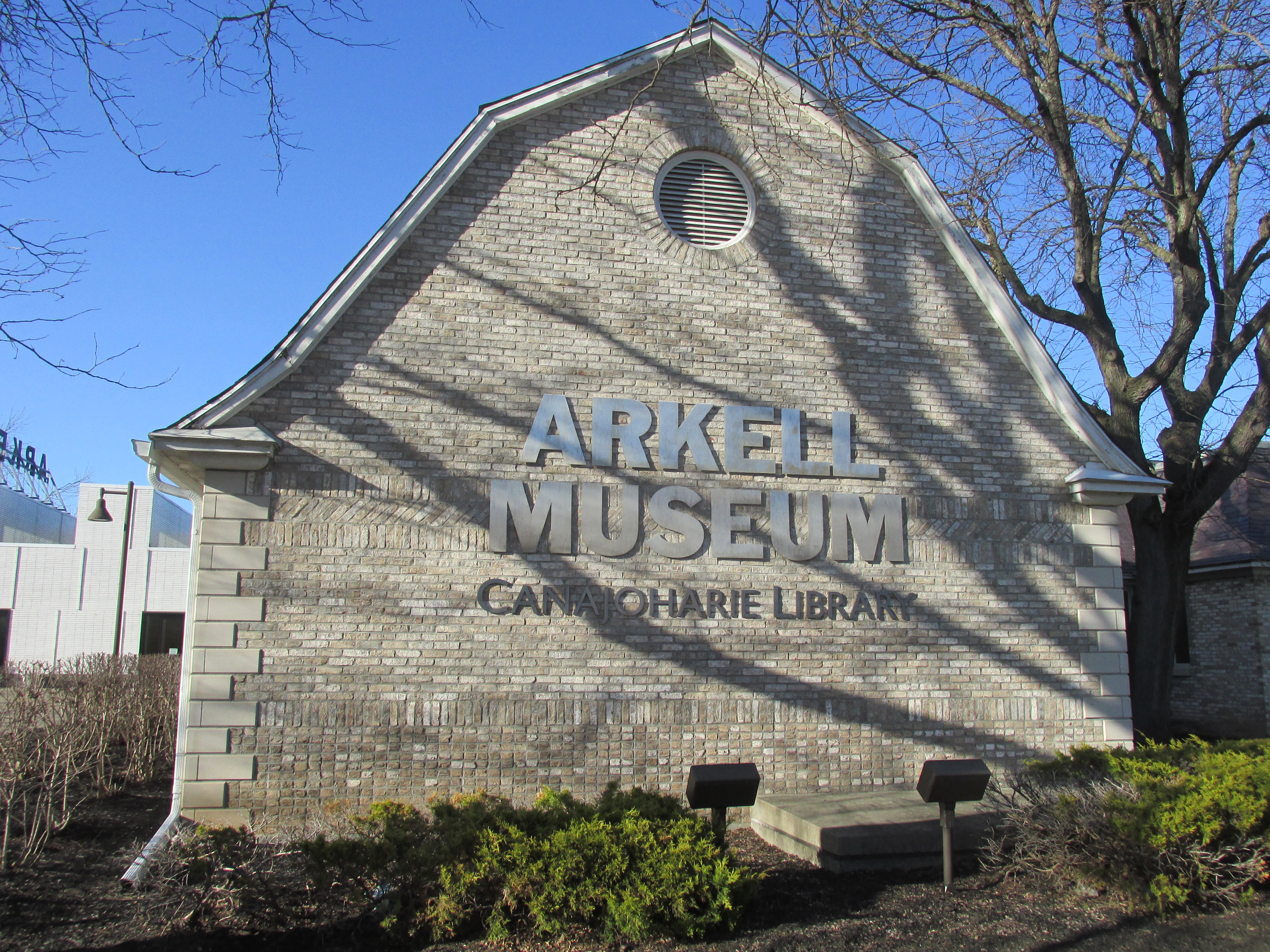
 ...and a more elaborate bronze plaque on the grounds of the Arkell Museum...
The Arkell Museum and its classic Dutch Colonial lines...

Bogaert and his fellow Dutchmen spent multiple days here both on their way to and from Oneida. His journal entries provide a glimpse of two very different cultures interacting with each other. On his return journey, perhaps eager to get back to Fort Orange asap, Van den Bogaerts went ahead solo. When darkness fell and he was unable to start a fire he ended up spending the whole night pacing back and forth in order to avoid freezing to death (as Clint Eastwood said "A man's got to know his limitations"). Van den Bogaert also had difficulty understanding why the Mohawks were reluctant to carry all of his gear in addition to their own. When traveling between villages he, his fellow Dutchmen, and the Mohawk guides would spend the night in what Van den Bogaert called "hunter's cabins". According to notes attached to the journal these trail houses were said to have been "built in response to dreams".


Once launched I headed upriver and avoided the strongest flow by hugging the north shore. The north shore also provided protection from the day's gusty northwest winds. The morning's earlier rain had stopped and skies were beginning to look more promising...

Stopped briefly at the mouth of Cayadutta Creek...

Continuing upriver I had for company a busy New York Thruway on the river's south side and an equally busy railroad on the north side. My on-the-water companions included this pair of long-tailed ducks...
.JPG)
After paddling about 4.5 miles the movable dam and lock 13 at Yosts (hamlet in Randall, NY) came into view...


The hill sloping down to the river is called "Big Nose". I'd arrived just in time to see Amtrak train 281 of the Empire Service making its way westward towards Utica...

Further upriver (between Lock13 and Sprakers) was "Keator's Rift" which Jeptha Simms in 1845 described as "the greatest on the river, having a fall of ten feet" in The Navigators by Philip Lord Jr.. Lord says the following of Spraker's Tavern located at Keator's Rift: "There was perhaps no more strategically placed tavern in the Mohawk Valley, situated as it was at the head of the most dangerous rapid on the river. Here boatmen bound downriver could fortify themselves for the run, and those lucky enough to make it up through Keator's Rift, could celebrate their success, or perhaps recover from disaster."
Noting the much faster moving water near Lock 13 I turned about and rode the current, sometimes as fast as 7 mph...

...back down to Fonda. Approaching the takeout near the Canal Maintenance facility I saw where all the buoys hang out...

Post paddle I drove along Route 5S which paralleled the river to Canajoharie where I found two historical markers commemorating General Clinton's 20-mile portage between Canajoharie and Ostego Lake:
This one (that's seen better days) along a steeply inclined Rock Street...


Every year the General Clinton Canoe Regatta holds an event commemorating Clinton's subsequent journey between Cooperstown on Ostego Lake and Bainbridge, NY some 70 miles down the Susquehanna River to where he linked-up with General Sullivan's force. Back in 2004 and 2005 a younger and stronger version of myself participated by paddling the 70 mile distance (fortunately in a downriver direction). At that time I didn't appreciate how many obstacles Clinton and his men had surmounted before ever reaching Ostego Lake.
The Sullivan-Clinton Expedition brought destruction to the Iroquois tribes who were aligned with the British during the Revolutionary War.
From Canajoharie I next drove further along Route 5S through Fort Plain and Sand Hill to the largest Mohawk village that Van den Bogaerts visited...

Bogaert and his fellow Dutchmen spent multiple days here both on their way to and from Oneida. His journal entries provide a glimpse of two very different cultures interacting with each other. On his return journey, perhaps eager to get back to Fort Orange asap, Van den Bogaerts went ahead solo. When darkness fell and he was unable to start a fire he ended up spending the whole night pacing back and forth in order to avoid freezing to death (as Clint Eastwood said "A man's got to know his limitations"). Van den Bogaert also had difficulty understanding why the Mohawks were reluctant to carry all of his gear in addition to their own. When traveling between villages he, his fellow Dutchmen, and the Mohawk guides would spend the night in what Van den Bogaert called "hunter's cabins". According to notes attached to the journal these trail houses were said to have been "built in response to dreams".
Thus ended my trip through the heart of Mohawk Country. However, before leaving the valley I enjoyed supper at a Palatine Bridge restaurant with a commanding view of the valley. While still in Palatine Bridge I encountered a horse and buggy at a traffic light on Route 5. Heading back to my hotel in Amsterdam I stopped to visit Schoharie Crossing. Here at the confluence of the Mohawk River and Schoharie Creek was located the Lower Village Tionontogen...

In 1712 the British built Fort Hunter adjacent to the village...

The Mohawks are said to have had three different clans to which tribe members belonged: the Bear, Turtle, and Wolf clans. With Tionontogen being for Wolf Clan and Caughnawag being for the Turtle Clan, I'm guessing that Tenotoge may have been where the Bear Clan people lived.
.
 The view is looking west, the direction in which Blackburn and his boat traveled. I can almost picture Blackburn up on the towpath to the right pulling his sloop along the canal. In Joe Garland's book Lone Voyager Blackburn claims "I had to tow the boat forty miles myself before I could get anyone to take her in tow. Then Captain Howard came along with two light boats. He agreed to tow me to Buffalo for thirty dollars. He carried a crew of three men besides himself and four mules." Blackburn had sailed the "Great Republic" solo across the Atlantic Ocean the previous year...despite his having lost most of his fingers and toes earlier in his life.
While at Schoharie Creek I also visited the remains of the aqueduct which once carried the Erie Canal over the creek. Back in 1902 Howard Blackburn and his 25-foot sloop "Great Republic" traversed the Erie Canal en route to the Mississippi River. He and his somewhat famous sloop would've made the crossing here...

In regards to the original people of the valley, it's encouraging to read of an ongoing effort to re-establish a Mohawk presence that had all but vanished in 1783. The community is called Kanatsiohareke and since1993 its founders are working to once again cultivate corn and other agricultural produce alongside the Mohawk River.
In addition to some of the historical sources mentioned, two movies offering a glimpse of the Mohawk/Jesuit relationship are Black Robe 1991 and Mission of Fear 1966.
Very little in the way of trash crossed my path over my time on the Mohawk...

4 comments:
HI THERE. Greetings from Iceland. Came across your site out of pure coincidence. Well, you´re trash paddler. GOOD JOB. So am I.
BTW I use to live in Boston in 1979. Went to David L. Barrett School. All the best. Orsi.
Hello Orsi and warm Earth Day greetings to you in far-from-here Iceland. Always good to hear from another trash paddler and former Bostonian. Best, Al
This report is fascinating! Thankyou for posting it. My father, a Spraker, grew up on the Mohawk in Canajoharie before WW 2, but I grew up in Ohio. I do remember the Spraker House and Tavern, (and the old family's old swan sleigh!) from visits, so many of the names and places you refer to are familiar to me from hearing my Dad talk about his childhood. I've just recently realized what a key role the Erie Canal played in opening up the west, making it possible for the products of that rich land to reach New York City. Understanding that it connected the East Coast to land and farms all the way to the Mississippi River is something I probably heard about in school, but hadn't really given much thought to. A number of years ago I found a poem, apparently written by a traveler along the river, called “Out in Spraker's Woods”. It describes what sounds like a good, old-fashioned German beer garden. The original Spraker settlers came from Saxony in the middle of the eighteenth century. The name “Sprecher”, German for “Speaker” or “Spokesman”, was anglicized at some point.
Hello Anonymous, Glad that you enjoyed the post and that it rekindled memories of where your Dad spent his childhood. Thank you for the information regarding the origin of the word "Spraker". Best, Al
Post a Comment