
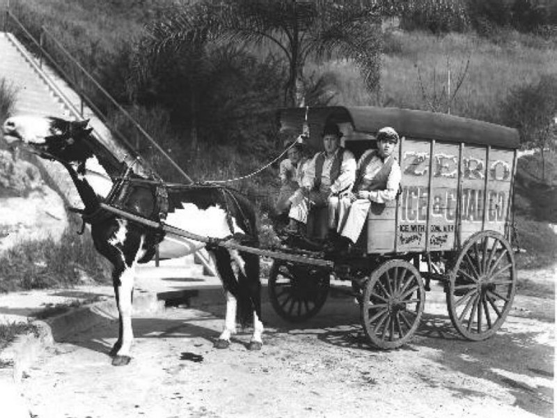
According to the Cambridge Chronicle's 1905 Industrial and Building Edition the company used a dedicated fleet of 75 freight cars, each car capable of carrying approximately 25 tons of ice. Twenty freight cars were loaded each day during the summer months and the train would travel by night to Somerville where the ice blocks would be transloaded from the rail cars so that 50 horse-drawn wagons such as this could then ply the streets of Cambridge and Somerville the following morning.
Squannacook Junction served trains from 1892 until it was discontinued in 1942. However, before it could be discontinued the Boston and Maine Railroad needed to build a bridge across the Nashua River in Pepperell in order to serve the mills on the west side of the river previously accessed via the Brookline and Pepperell Branch. The ice trains had stopped running in the late 1930s. Much of the roadbed between Squannacook Junction and Brookline, NH remains today, although the rails and crossties were removed during World war II.
At any rate, Squannacook Junction not only served to connect train tracks, but also connected some great sounding Native American place names such as Squannacook River, Squannacook Hill, Nashua River, Nissitissit River, Muscatanipus Pond, and Muscatanipus Hill.
So, in honor of the recent good news concerning the Mashpee Wampanoag tribe finally getting approval from the federal government to place some of their land into a trust, I figured paddling up the Squannacook River to the junction might be a good idea on, yet another, beautiful Sunday morning.
This is the view entering the Squannacook from the Nashua River...


Upon turning about I saw one of the few remaining Cardinal flowers of the season...


Back where the river passes close to the Peterborough and Shirley Branch I exited my boat and headed west along the abandoned tracks...

Later, after studying the topo maps more closely, I drove to West Groton and hiked down the Peterborough and Shirley Branch about half a mile to where I finally came upon Squannacook Junction...

From this spot the line ran 13.86 miles in northward direction following the Nashua and Nissitissit rivers to Muscatanipus Pond (aka Lake Potanipo)...

Yesterday, intrigued to explore the place where the ice originated, I drove to Muscatanipus Pond in Brookline, NH known these days as Potanipo Lake...

Though the name has been altered and shortened it should be noted that in Edward E. Parker's 1906 History of Brookline, formerly Raby, Hillsborough County New Hampshire it is explained that Muscatanipus is the original and correct name. Parker states the name means "Great Bear Pond".
In the earlier mentioned Cambridge Chronicle 1905 article the pond and its waters are described thus: "Situated among the rocks and woodlands of the Old Granite State, about sixty-five miles from Boston, is the little town of Brookline, secluded, peaceful, and picturesque. About a mile north of the village, some ninety feet above its level, half hidden by primeval forests and granite hills, lies a lake, the source of the Nissitissit river. The lake, itself fed by two mountain streams and innumerable crystal springs, gets its name from the Indians, who pleased with the clearness and purity of its waters, called it in their language, Muscatanapus - The Great Mirror.....The company has the reputation of cutting the purest ice in the country and this fact is admitted by experts who have analyzed and scientifically examined it. The appearance of the ice-its delicate blue tinge and great transparency indicate the purity it possesses."
Sounds similar to today's advertisements for 'mountain spring' bottled water.
I launched very close to where the Nissitissit River flows out of the 250 acre pond...

The Brookline and Pepperell branch crossed the Nissitissit just before reaching the pond at the spot where this pedestrian covered bridge stands today (on the old railroad bridge supports)...

Paddling away from the launch one sees quite a cluster of white wooden buildings along the eastern shore. This is where there once stood what some claim to have been the largest ice storage facility (under one roof) in the world, The Fresh Pond Ice Co...


The Brookline, NH Historical Society's website has some great old photos of the ice trade and the railroad.
Traveling to the pond's north side I looked back towards Muscatanipus Hill...


Returning to the pond I noted my first fall foliage...

I thought I heard this heron shout "hey iceman"...

Before leaving the pond I pulled these 2 old half-pint milk bottles from the shallows near where the ice house was located...

The diminutive bottles reminded me of how the term "Half Pint" came to be used in describing folks vertically challenged.
Another term "blockhead" and can best be explained by this.
Leaving the area I drove past this well preserved remnant of the Brookline and Pepperell branch...

Trash recovered from the Nashua and Squannacook on Sunday...

Trash recovered from Muscatanipus Pond yesterday...

3 comments:
Nicely done! I'm from Pepperell and there are (very) few places that discuss the Brookline/Pepperell railroad branch of the Fitchburg RR, that was located on the West side of the Nashua River up through Pepperell.
Thanks for your great article. I am writing a story of the seven railways that crossed Groton and your article was very helpful. Do you know if all ice shipments were at night- or just summer as u said. I heard that the Fitchburg r had agreed to carry at least 50,000 tons per year. Also, was the ice house stop on the main line or on a separate spur
Ken hultgren. Lunenburg
978 407 8310
Hello Ken, I don't know if there were daytime runs with ice. Imagine with equipment issues and or delays there were occasions where they did run in the daytime. I also don't know whether there was a siding or the cars were stored on the mainline. The 1936 USGS map of Groton shows the line continuing to the north past Potanipo Pond but it may have done so only briefly. Wish I knew more. Perhaps the Brookline Historical folks or the Boston and Maine RR Historical folks could provide answers. Best of luck with your project. Al
Post a Comment