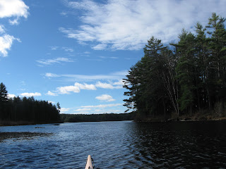
Temperatures early this morning were in the upper 30's and yesterday's busy wind had backed off a bit.
From my launch site, I headed upriver (opening photo) planning to explore the part of the river least altered by man.
As I proceeded in a northerly direction, the river opened up into a pond...
My goal was to find the river's entry point at the pond's north end and continue further upriver towards the adjacent state in which the river rises. Once the entry point into the pond was located, there were obstacles such as the one pictured below to overcome...
Thanks to recent rains, this beaver dam and 2 others like it were able to be ascended without my having to leave the cockpit.
For a while things were looking good as I proceeded further north towards the hill and some power transmission lines in the distance...
However about a mile above the pond the channel became too narrow for my craft and I turned back.
A little downstream of the pond, I stopped for some brunch and enjoyed this view to the south...
Upon arriving at where I'd launched, I continued under a bridge and a little further downriver came to the river's confluence with a brook flowing in from the east...
The brook had just finished a dramatic drop of 200' in five falls enroute to this spot.
Below this point the river opens up into a man-made lake created back in the 1940's for flood-control purposes...
The river in question had crystal clear waters and there was very little trash to be found. Of the 6 pieces of trash recovered, 3 were in the river and 3 were at the boat launch. YTD = 6195
Can anyone guess the name of the Native American's dog? The dog's master may have been from the area to the south known, then, as Pequoig. Have I provided enough clues?


4 comments:
Tully
You got it Bernie! It was the East Branch of the Tully River.
Tully the dog must have been very popular as his name is all over the area: Tully Brook, Tully River, Tully Lake, Tully Dam, and Tully Mountain.
The brook that enters the Tully after dropping through Doane's Falls is Lawrence Brook.
I launched at the Tully River Canoe Launch on Doane Hill Road in Royalston. The area is nicely maintained by the U.S. Army Corps of Engineers.
Great place to paddle, but I remember a lot of beaver dams. You can also hike over to Spirit Falls.
Erik, Yes, there are still many beaver dams which must be difficult at low water levels. I'll have to check out Spirit Falls on my next visit.
Post a Comment