Monday, November 7, 2022

The Nest Will Rise Again


The highlight of this past week for me was seeing on Friday that the Assabet River eagle nest is in the process of being rebuilt.  Back on August 10th the nest was completely gone...

...and had me wondering if the eagles had decided to relocate.  Guess it was just a "tear-down and rebuild".  Prior to the tear-down the nest looked like this...

As compared to the opening photo, there's still a lot of stick placement yet to be done.

One of the adult pair was in a nearby tree on Friday...

...perhaps taking a break.

Ospreys were also seen on the Assabet Friday.  This one with a fish...


Ducks will need to be extra careful when in the vicinity of this recently constructed duck blind...


Another Assabet River development noted this past week was the strong slug of clear water rushing into the river  through the Fort Meadow Brook box culvert... 

I believe the city of Marlborough, MA is lowering the Fort Meadow Reservoir water level as it did last year starting on November 1.  According to the website FraminghamSource.com the approximately 250-acre  reservoir was lowered in 2021 by about 4 feet at a rate of 2 to 3 inches per day.  The lowering was done to allow for control of invasive weeds (milfoil, fanwort), reduction of Asian clams, and to allow for shoreline-structure repairs.  It was good to see the Assabet receiving such a strong flow of crystal-clear water and how it swept away much of the river's floating duckweed...


Yesterday I paddled the lower Assabet River between Westvale and Egg Rock in Concord, MA and found the river still enjoying a boost in current thanks to the inflow from Fort Meadow Reservoir.  By the way, despite its name, Fort Meadow Reservoir hasn't been used as a drinking water supply for many decades.

Earlier in the week, on Thursday, I paddled some of the Charles River in Millis, MA...

...between Dwight's Bridge and about a mile upstream from the boat launch at Forest Road.  There are plenty of bends in this stretch of the river and that caused me to surprise a pair of river otters.  Could only get a photo of one...


For me encounters with river otters are few and far between.

Two Trustees of Reservations properties are located along this stretch of the Charles:


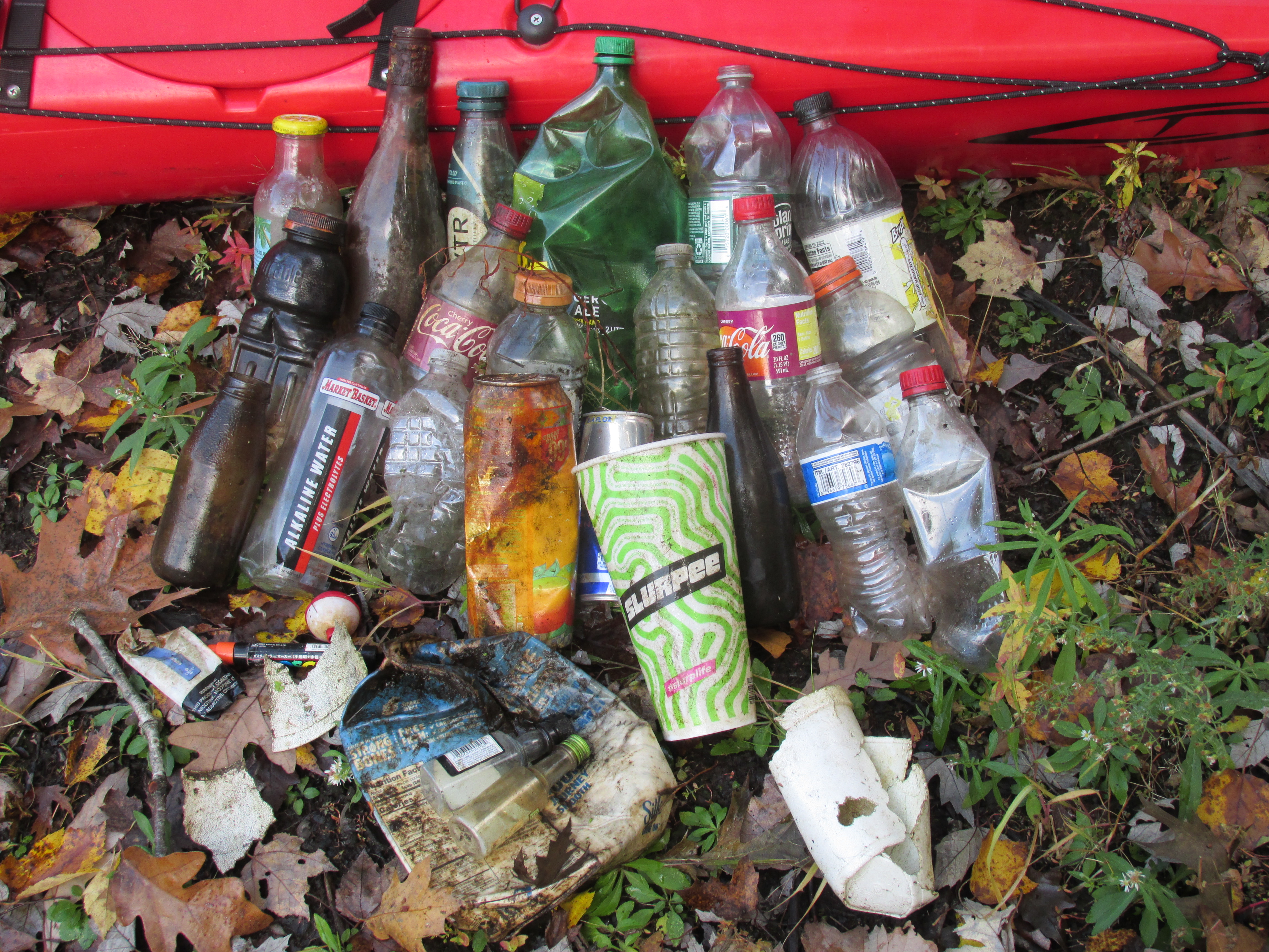
Trash was light this past week:

Thursday's on the Charles...


Friday's on the Assabet...


Sunday's also on the Assabet which included a "Smoker's Outpost" plastic cigarette-butt receptacle...


Some recent beaver work seen on the Assabet:

Hope the beaver is careful making its final knaws!


Nearby was what looked to be a beaver training exercise...


Another very welcome development this past week was unseasonably warm temperatures...60s and 70s (F).  Unreal considering what the calendar says!  Lots of boaters out on the river yesterday enjoying the warmth.  Felt more like September!!!


Monday, October 31, 2022

Not Run of the Mill


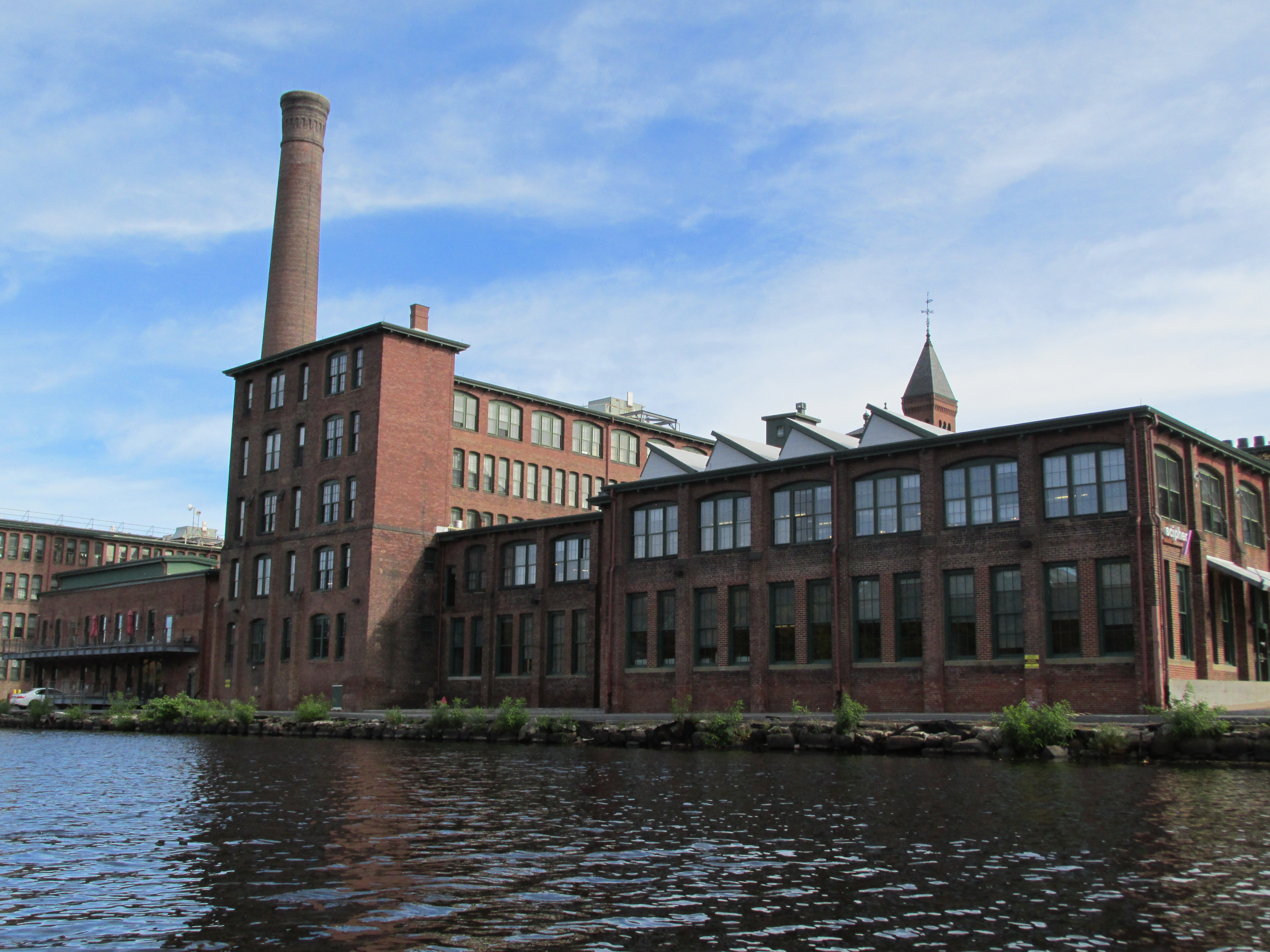
This past Friday found me paddling down the Charles River in Waltham, MA to the above pictured Boston Manufacturing Company mill below the Moody Street Bridge.  This mill was built in 1814 and is said to have been the first place in America where raw cotton was transformed into finished cloth all under one roof.  In the mill's early days the machines used in manufacturing were operated by young women known as "mill girls" who lived in company-owned boarding houses.  They worked an 80-hour six day work week.   This system of manufacturing was called the "Waltham System".   While I'd known of the Boston Manufacturing Co. mill and the role it played in America's Industrial Revolution I didn't really grasp how it was a departure from an existing system of mill operations known as the "Rhode Island System".  The Rhode Island System was the pattern developed by Samuel Slater at his 1793 mill on the Blackstone River in Pawtucket, RI.   Today the Boston Manufacturing Co. mill houses the Charles River Museum of Industry and Innovation which is a museum of the American Industrial Revolution.  

A few days earlier on Wednesday I'd paddled the Assabet River between the Hudson Light Plant and the dam at the Gleasondale Mill...

Post-paddle while researching the history of the Gleasondale Mill I came across a study done for the Stow Planning Board by the UMASS Center for Economic Development which mentioned the Gleasondale Mill being "a classic example of the Rhode Island System"... and describing the Rhode Island System as where mill  "owners attempted to replicate the patterns of traditional New England life for their employees.  Company-owned houses were built near the mills, to accommodate workers and their families.  Schools, stores, and churches soon followed."  According to the study the first textile mill at Gleasondale was built in 1813 when the village was known as Rock Bottom. This is just one year before the Boston Manufacturing Co. mill was built in Waltham.   Thus these two mills were built around the same time, on different rivers, following different systems of operation.  As I understand it the Rhode Island System created mill villages, whereas the Waltham System went bigger and created mill cities such as Lowell, Lawrence, and Manchester, NH all on the Merrimack River.   

Being out on the Lakes District of the Charles River in Waltham on a late October day was a treat...

...and there was still some fall foliage to be enjoyed...


The Waltham Watch Factory maintains its commanding presence alongside the river...
...and I believe this facility followed the "Waltham System" in the mass production of watches.

Getting back to my earlier paddle on the Assabet River I encountered this fellow seemingly sunbathing on a cloudy day with occasional drizzle...

...a northern water snake I believe.

When I came by a little later the snake wasn't there but this hawk was observed in a tree near the same spot and appeared to be drying its wings...

Wrapped up the week with a paddle yesterday on the Sudbury River between Sherman's Bridge in Wayland, MA and Fairhaven Bay in Concord...

Lee's Bridge from the Lincoln side...

Unfortunately the bridge has been tagged with graffiti for the first time that I'm aware of.


Trash for the week included 60 nip bottles and a fair bit of Styrofoam in addition to plastic containers:
Wednesday's from the Assabet...

Friday's from the Charles...


Sunday's from the Sudbury...

This plastic bag seemed appropriate on Sunday with it being the day before Halloween...


Monday, October 24, 2022

An Almost Replenished Assabet

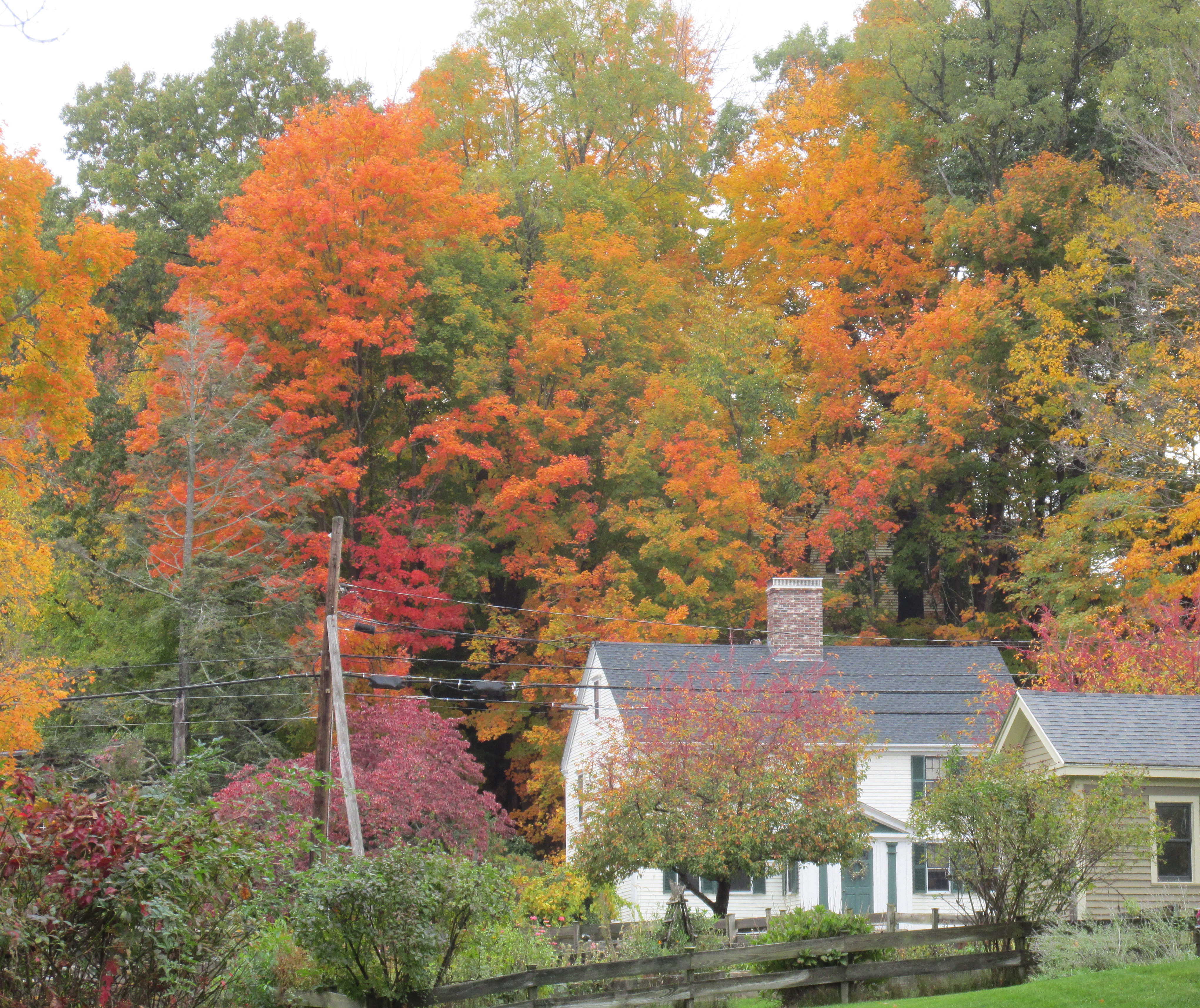
On Tuesday I found the Assabet River replenished enough to allow my boat and me passage between Spencer Brook and Damon Mill.  My trip was made easier thanks to somebody's fairly recent chain-saw work in the Westvale area.  After working my way against the Assabet's current I pulled into the Damon Mill's outlet canal where I got this view of the Col. Roger Brown house amidst some fall foliage...

The building dates to the early 1700s and it is said that Concord Minuteman Roger Brown was doing carpentry work on the house on the morning of April 19th, 1775 when he got the news that British troops were on their way to Concord.

It was good to, once again, see the Assabet River with more water than rocks and sand bars...

...especially in the area of Concord Junction where this MBTA locomotive pushed its inbound commuter train across the river.

On Sunday, I paddled the lower Assabet between Spencer Brook and Egg Rock.  Upon reaching the confluence I continued down the Concord River to Saw Mill Brook passing along the way the spot where Roger Brown and the other Minutemen encountered the British troops at Concord's Old North Bridge...


The Assabet offered an assortment of wild things including this red-tailed hawk...

...these mushrooms gradually becoming submerged...

...and this late blooming wildflower...
...that looked like a relative of a Cardinal flower.

Sandwiched between those paddles was a visit to the Bill Ashe boat launch on the Nashua River (Oxbow NWR) in Devens, MA where I slid into the river from the launching pad...


Headed downriver...

...to the Ice House Dam where water is flowing over the dam again...


Between the dam and a point upriver above Route 2 this stretch of the Nashua produced its usual batch of plastic trash including 29 nip bottles...


One odd find in the Nashua was a 20 liter dry bag that had been in the river for quite awhile based on the amount of river staining on it.  When cleaned up later it was revealed to have a built-in solar panel which once powered a set of light bulbs and could also recharge a electronic device through a USB terminal...


While I doubt the solar panel will generate electricity again, the bag itself will soon see service as a trash receptacle.


 Tuesday's trash from the Assabet...


Sunday's from the lower Assabet and upper Concord...


Tuesday, October 18, 2022

Skitchewaug's Fertile Intervale


I wasn't planning another trip to Vermont this fall...but then I came across A Prehistoric Inventory of the Upper Connecticut River Valley by Daniel Cassedy.  One of the sites he listed in his inventory was the Skitchewaug Site alongside the Connecticut River where Native American corn found in storage pits was radiocarbon-dated back 1100 years. Because of this he wrote that the site was "...one of the most significant sites currently known in the Northeast."  After reading this it took only a few weeks until I found myself looking upriver from the Skitchewaug Site shoreline this past Sunday morning (above photo).

I'd launched at the confluence of the Black and Connecticut rivers at about 8am.  The air temperature was about 40 degrees whereas the water being much warmer resulted in considerable fog ...

The Skitchewaug Site is located where a fertile floodplain stretches from the mountain's base over to the Connecticut River...


In a paper for the Journal of Vermont Archaeology (Vol. 12, 2011) titled Western Abenaki of the Upper Connecticut River Basin: Preliminary Notes on Native American Pre-Contact Culture in Northern New England  R. Duncan Mathewson III states "Quite clearly Skitchewaug Site represents a major village settlement on the west bank of the Connecticut River some 500 hundred years before Contact times and into the Protohistoric Period."  Hard for me to wrap my head around the fact that Native Americans planted and harvested corn in these fields for eleven hundred years.  That's more than 13,000 full moon cycles!

Further upriver the floodplain widens out even more and these few remaining corn stalks...

...speak to one of Mathewson's conclusions: "The presence of corn in all seven storage pit features at Skitchewaug has been interpreted by Heckenberger et al. (1992) as indicating that corn was an important diet staple rather than simply a diet supplement."

Returning to my boat I found the sun finally breaking through the fog and the day was improving by the minute.  I followed the river bank up as far as the now submerged (I guess) Glidden Island before heading back downriver.  The view of Skitchewaug Mountain from near where Glidden Island used to be...

The person having the best view of Skitchewaug Mountain and the river alongside it was this guy...


On the way and about a half mile below Skitchewaug I thought about the Wentworth Ferry and the role it played in linking sections of the Crown Point Road which connected the Fort at No. 4 in present-day Charlestown, NH and the fort at Crown Point on Lake Champlain.  Soldiers beginning the trip from the Fort at No. 4 on the New Hampshire side would march about 2 miles to a point where the ferry would take them across the Connecticut to the Vermont side.  The only spot I could find on the river's west side where the riverbank looked suitable for a ferry landing was this one...


It's approximately 900' south from these two historical markers:

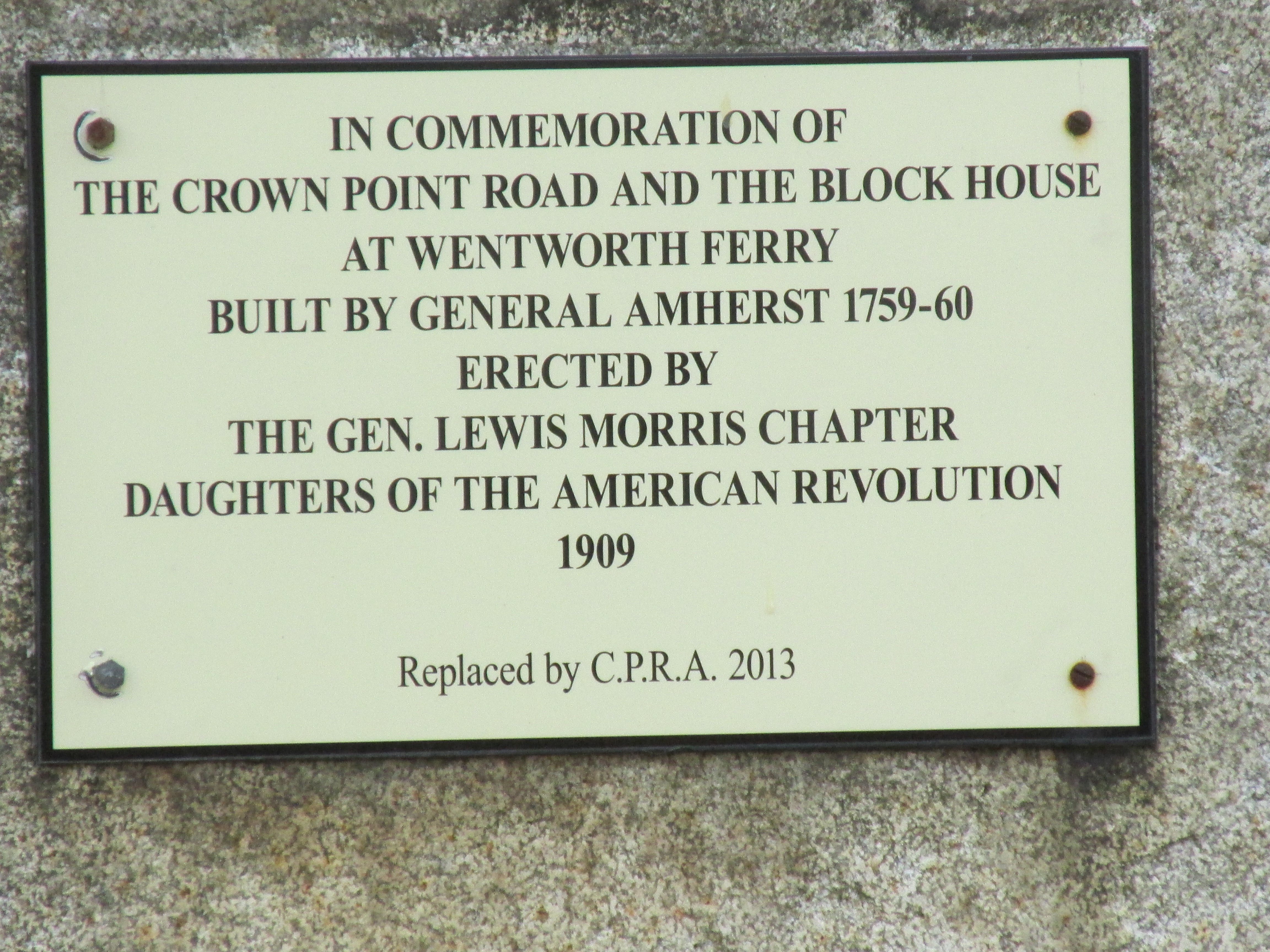
A plaque on a large stone pertains to both the ferry and the Crown Point Road...


...and an additional marker for the road...

According to the Crown Point Road Association the road was built per the order of British General Jeffery Amherst upon his having gained possession of both Ticonderoga and Crown Point, both key forts on Lake Champlain during the French and Indian Wars.  In order to advance further north towards French controlled Canada he needed a reliable supply route to and from the Fort at No. 4 some 70 miles to the southeast.  Part of his order for building the road stated "...the most direct line possible to No. 4 clearing the forest all the way you go and widening it in every part to at least 20 feet....".  On the association's website, crownpointroad.org, there are GPS coordinates for the road's remaining stone markers.  The coordinates were recorded by Hunter Melville and are a great help to those looking to locate them. 

On my drive home I visited some related historical markers in Charlestown, NH near the spot where the Crown Point Road terminated at the original Fort at No. 4...


Fort at No. 4 was actually located about a mile and a half south of the fort's present-day replica.

This additional marker mentions Gen. John Stark's 1777 march to the Battle of Bennington...

His route to Bennington is known to have taken him through Manchester VT leaving me to wonder if he and his men crossed the Connecticut via Wentworth's Ferry and followed the Crown Point Road for part of the way.  If so, it would have been fitting as he'd played a role in building the Crown Point Road some 18 years earlier.


Earlier last week I got out on the Sudbury and Assabet rivers. The Route 27 Bridge over the Sudbury in Wayland showed some fall colors...

...and an osprey did some fishing...


My paddle on the Assabet River in Stow provided additional fall foliage at the Assabet Overlook...

...and the Assabet showed plenty of wildlife with swans, ducks, geese, as well as this hawk...

 ...this bald eagle...

...and this white-tailed deer wearing its darker winter coat...

My photo of trash from the Sudbury River was accidentally deleted but consisted of the usual culprits... half a dozen or so plastic bottles.


Trash from the Assabet...


Sunday's trash from the Connecticut River also known as the "Kwenitekw" to the Abenaki people...