
This 1755 British map (crude red line is mine) shows the approximate route the Maliseets and Allan are believed to have followed...
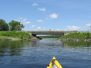
I decided to visit some of the places they passed through, especially spots that had undergone the least physical change since 1777. I picked up their trail where they would have been approaching Old Fort Meductic where they'd leave the St. John River and begin their first major portage over the Maliseet Trail...
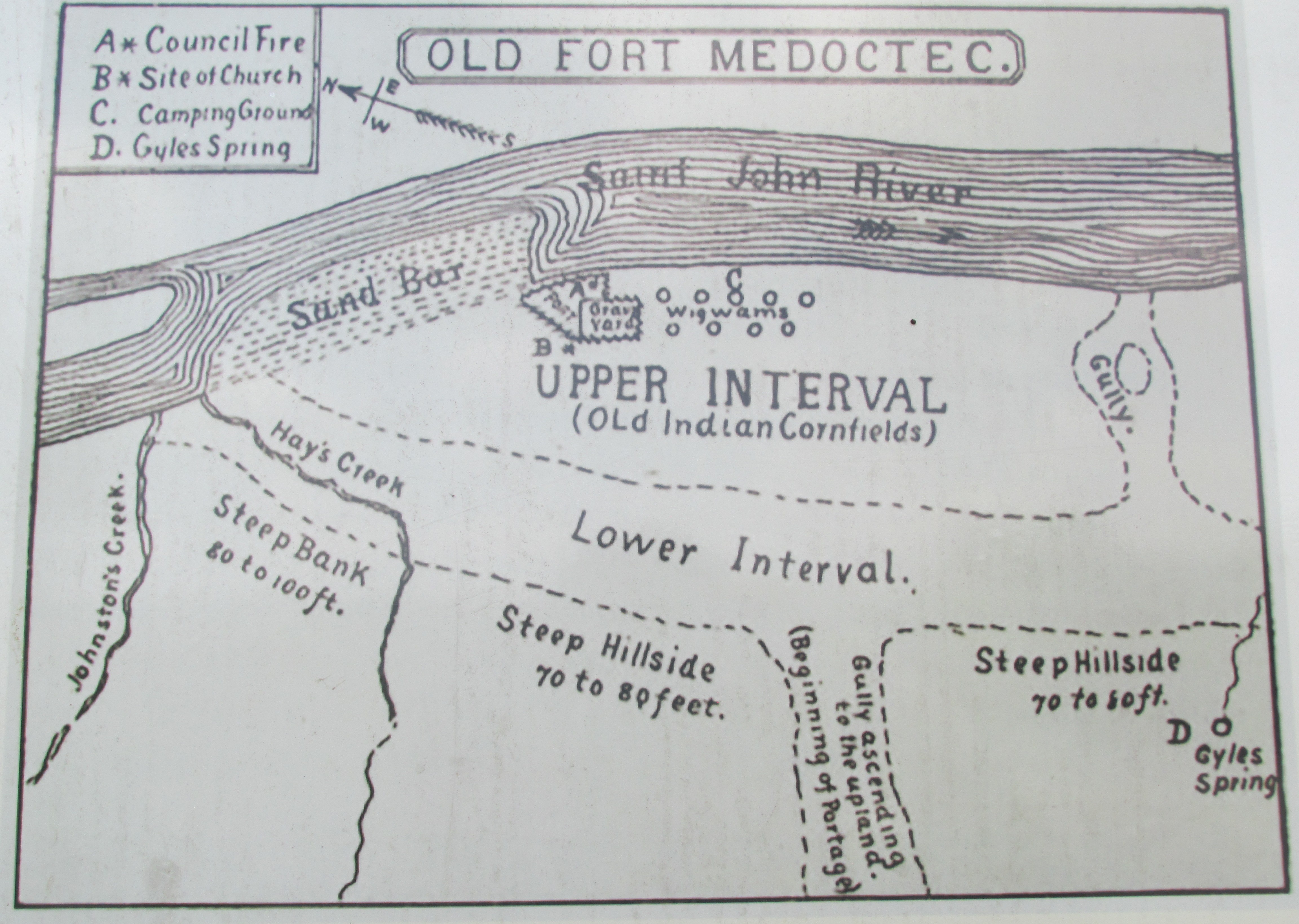
A drawing by W. O. Raymond shows the area as it was in 1896. The building of the 660-megawatt Mactaquac Generation Station (downriver) in 1968 submerged the interval areas depicted by Raymond's drawing...


After paddling above the submerged village and fort I paddled back to the takeout. Before taking out I ventured a short distance up the Eel River where loons were seen hanging around...
 Unfortunately the plaque is missing. I then drove a bit further on Rt.165 to the trailhead for the Maliseet Trail located in Hay Settlement across the road from the buildings seen earlier from the river...
Bear claw trailmarkers...
 I tried to imagine a whole tribe, including men and women, both young and old, children, infants, and the sick traversing such a difficult uphill portage while carrying canoes and everything they own.
 Short video of same which requires rotation...
 ...near where the original portage trail ended and the Maliseet would have re-launched their canoes and paddled up the Eel River...


 ...to where I could locate the narrow entrance to the mile-long Thoroughfare...

 While I could paddle back and forth across the borderline I had to be careful not to set foot on the side opposite from which I'd launched as doing so would constitute an illegal entry. Eventually the Thoroughfare delivers paddlers to the upper Chiputneticook Chain of Lakes...
 Here the Maliseet continued paddling down the 35-mile long chain of lakes while I headed back to the takeout at North Lake Provincial Park.

 ...I found this odd pairing...

The Maliseet would leave from a long cove in Big Lake and portage to a stream leading to the north end of Crawford Lake in Crawford, ME. That's where I briefly picked up their trail again. Their view down Crawford Lake...
Passed this totem pole along the lake's east shoreline...


As I neared Gyles Cove a pair of adult eagles let me know I was almost there...

Heading out to the middle of the river afforded me this view of where the Maliseet may have begun the nearly 5-mile long portage...

...a closer look...


Post-paddle I drove along Rt 165 to Fort Meductic Road where this historical marker for the fort/village was erected in 1924...


...led me along the ancient and well-worn portage route...

The original portage trail was almost 5-miles long but presently the trail ends after about 0.75 miles where the Trans-Canada Highway blocks further passage. However, a short distance from the highway the a side trail leads to this 80-foot high waterfall on Hay Brook...

The waterfall provided a cool spot to rest before hiking back out to my car. Next I drove to this covered bridge over the Eel River in Benton, NB...


Upon reaching First Eel River Lake they would leave the St. John watershed and follow the Metagmoughschesh Portage about 3-miles to North Lake, a headwater of the St. Croix River. A Baptist church stands there today perhaps not far from the old portage trail...

I launched at the North Lake Provincial Park in North Lake Parish, NB and paddled to the spot where I'd guess the Maliseet once again re-launched their canoes...

Then I followed their route down the beautiful lake for about 2 miles...


A cottage along the Thoroughfare had this message which I can relate to...

This was an interesting place to paddle as the narrow Thoroughfare threads the border and different time zones between Canada and the United States. At the narrowest spot it passes under the bridge connecting the US and Canada...

Both countries maintain docks for Border Patrol vessels. The US dock and vessel...


The Maliseet are said to have followed the St. Croix River down to Grand Falls where they took a right turn and paddled up the St. Croix's west branch to Big Lake (Passamaquoddy or Genasorganawgum lake) in present-day Princeton, ME. Instead of rejoining their route at Princeton I launched at Greenlaw Chopping Landing at Big Lakes western end and paddled up Grand Lake Stream to the bottom of Little Falls...

...in hopes of seeing a petroglyph. In checking out this prominent boulder at the base of the falls...


Not sure if they're both just soaking up the sun or if one is about to dine on the other. At any rate no petroglyphs were seen. Back out on Big Lake I did get to paddle within sight of the lake's largest island now known as Kuwesuwi Monihq which was recently re-acquired by the Passamaquoddy Tribe and is considered by them to be a sacred place...

The Maliseet would leave from a long cove in Big Lake and portage to a stream leading to the north end of Crawford Lake in Crawford, ME. That's where I briefly picked up their trail again. Their view down Crawford Lake...

Passed this totem pole along the lake's east shoreline...

This immature eagle was perched nearby...

From the lake's south end the Maliseet entered the East Machias River...

...which they paddled and portaged the final 30 miles or so to Machias. Only 11 days after their August 2nd arrival the British mounted an amphibious assault on Machias. The Maliseet joined with local militias in successfully repelling the assault. Today because of the Treaty of Watertown all Maliseet are allowed to join the United States Armed Forces regardless of their nation of birth. It appears the Maliseet more than lived up to their part of the Treaty of Watertown. Was their trust in Col. Allan well placed? Did he perhaps make promises he couldn't later fulfill?
In reading of Col. Allan's earlier exploits around the mouth of the St. John River I again encountered mention of the British warship HMS Vulture. It was the Vulture's presence that played a role in Col. Allan and the Maliseets deciding to retreat from the area and travel to Machias. I'd last encountered mention of the HMS Vulture in the Hudson River in New York. On that occasion the Vulture was the vessel Benedict Arnold escaped on after committing treason at West Point.
While in New Brunswick I found lodging in Woodstock, a classic river town at the confluence of the St John and Meduxnekeag rivers. Woodstock is located about 12 miles upriver from Meductic and is also home to a Maliseet First Nation community which more than likely includes descendants of those who made the journey to Machias back in 1777...

My favorite culinary experience while in Woodstock happened on June's hottest day. Looking for an air-conditioned spot I stumbled upon an A & W Canada where I enjoyed the frostiest mug of real root beer and the tastiest burger to cross my lips in decades. It was like an oasis and brought me back to the 1950s.
Spent 3 nights in motels but wanted to spend at least one night in a tent (without having to go through the trouble of bringing one, setting it up and later breaking it down). Solution was my very first Glamping experience at Cold River Campground in Eddington, ME where I slept in a yurt-shaped tent. Inside the tent was a full-sized bed, table, fan, and electrical supply. All I had to provide was a set of sheets, pillow, and a tired-from-driving body. I can live with the guilt.
During my paddles (and hike) in New Brunswick and Maine I encountered hardly any trash at all...just this...

North Lake Provincial Park was clean as a whistle perhaps in part due to these well-appointed receptacles...

No comments:
Post a Comment